Introduction
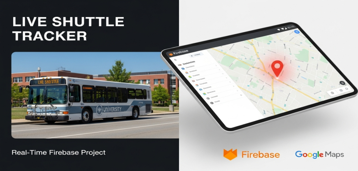
The University Shuttle Tracker is a web-based application designed to provide real-time location tracking and historical route data for a university shuttle service. The primary goal of this project is to offer students, faculty, and administrators a convenient and efficient way to monitor the shuttle's current position and review its past movements. By leveraging modern web technologies and a real-time database, the application delivers a seamless and instantly updated user experience.
User Flow & Functionality
The video demonstrates a complete user journey through the application's core features:
-
Authentication: Users begin at a secure User Login screen where they enter their email address and password to access the system.
-
Live Dashboard: Upon successful login, the user is directed to the main dashboard. This screen is the central hub of the application and is divided into two main sections:
-
Live Location Map: An interactive map (powered by Google Maps) immediately displays the shuttle's most recent known location with a distinct red marker. A status text, "Last Updated," indicates how recently the location was received (e.g., "14 days ago," which updates to "a few seconds ago").
-
Past Locations List: To the right of the map, a running list of the most recent location pings is displayed. Each entry includes the location's address and a relative timestamp (e.g., "a few seconds ago," "14 days ago").
-
-
Real-Time Data Synchronization: The video showcases the application's most powerful feature. By manually adding a new location document (with latitude, longitude, and a timestamp) into the Firebase Cloud Firestore database, the web application's dashboard updates instantly without requiring a page refresh. The map marker moves to the new coordinates, and the "Past Locations" list is prepended with the new entry, demonstrating a live, real-time connection to the backend.
-
Historical Data Retrieval: The user navigates to the "Previous Locations" page using the top navigation bar. This feature allows users to look up the shuttle's activity on a specific past date.
-
Date-Based Filtering: On the "Previous Locations" page, the user can select a date from a calendar widget and click the "Fetch Locations" button.
-
Historical Route Display: The system then queries the database and displays all the location points recorded for that specific day. The results are presented both visually on the map and in a detailed list showing the location and the exact date and time of the recording.
-
No Data Handling: The demonstration also shows that if a date is selected for which no location data exists, the application gracefully handles this by displaying a "No Record Found" message.
Key Features
-
Secure User Authentication: A standard login system ensures that only authorized users can access the tracking information.
-
Real-Time Live Tracking: An interactive map provides an at-a-glance view of the shuttle's current position.
-
Instantaneous Updates: The application is built to reflect backend data changes in real-time, providing users with the most current information without manual intervention.
-
Historical Location Lookup: Users can query and visualize the shuttle's complete route for any given day in the past.
-
Intuitive Date Filtering: A user-friendly calendar interface makes it easy to select and retrieve historical data.
-
Dual Data Visualization: Information is presented both visually on a map and textually in a list, catering to different user preferences.
-
Clean User Interface: The application features a simple, clean, and organized layout with a clear navigation structure (Dashboard, Previous Locations, Feedback, etc.).
Technology Used
Based on the visuals and functionality demonstrated in the video, the following technology stack can be inferred:
-
Backend & Database: Firebase Cloud Firestore. This is explicitly shown and is the core of the real-time functionality. Its real-time listeners (onSnapshot) are likely used to push data updates to the client automatically.
-
Authentication: Firebase Authentication. Given the use of Firestore, it is highly probable that Firebase Auth is used to manage user logins.
-
Frontend: HTML, CSS, JavaScript. The dynamic nature of the interface, API integrations, and real-time updates are driven by JavaScript.
-
Mapping Service: Google Maps API. The embedded map, markers, and likely the reverse geocoding (converting latitude/longitude coordinates into readable addresses for the lists) are powered by the Google Maps Platform.
Potential Enhancements
This project serves as an excellent foundation that could be expanded with additional features:
-
Route Animation: Animate the shuttle's path between recorded points for a given day to provide a "playback" of its journey.
-
Multi-Shuttle Support: Add the ability to track multiple shuttles, allowing users to select which one to view.
-
Estimated Time of Arrival (ETA): By defining shuttle stops, the system could calculate and display ETAs for users.
-
User Notifications: Allow users to subscribe to alerts, such as when a shuttle is 5 minutes away from their designated stop.
-
Admin Panel: Create a separate interface for administrators to manage shuttle data, view analytics (e.g., route efficiency, peak hours), and manage user accounts.
Conclusion
The University Shuttle Tracker is a well-executed and highly practical application that effectively solves a common problem on university campuses. Its standout feature is the seamless real-time data synchronization, which provides an accurate and reliable user experience. By combining a powerful backend like Firebase with a user-friendly frontend and the Google Maps API, the project successfully delivers on its promise of live and historical shuttle tracking, ultimately enhancing convenience and planning for the entire university community.